|
Journey direction :-
Sudbury - Bures - Wormingford
|
|
Willow Trees
As you approach Bures
you will find both sides of the embankment lined with Willow trees.
These are grown commercially and cut on a rotational basis each
year with the timber being turned into Cricket Bats.
|
|
|
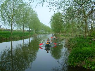
Pill
Boxes
As you journey along the river from Sudbury you cannot help but
notice the proliferation of Pill Boxes along the embankment
These can be seen along the entire stretch of the river between
Sudbury and Bures and they are all located on the Essex side of
the river.
At Bures they change course and follow the railway line to Chappel.
From Chappel they then follow the River Colne all the way to the
sea.
The majority of people think these
boxes were erected randomly, far from it.
They were part of the Eastern Defence Line which stretched form
West Mersea to Sudbury and beyond.
There were other Defence lines in the south of England which were
intended to hold back the Germans if they ever invaded the UK.
They were all built to a standard
design. At the end of hostilities the farmers were paid to knock
them down, paid something like £5 or £30. However they
proved nearly impossible to dismantle, so they took the money and
left them standing
|
|
|
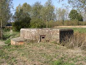
Scout Hut
and Allotment area
At the end of the Croft near to the Scout Hut there is an expanse
of Poplar and Willow trees, These were owned by Mr Deaves (purchased
1930) who installed a saw mill to deal with the timbers. During
the early part of the 1939 war, the sawmill was commandeered by
the armed forces to supply them with timber. The Garrison engineer
increased the width of the Croft to accommodate the larger vehicles.
The remains of the wood can clearly
be seen where the River Stour Boating canoes take their first break
on their journey to Cattawade.
Apart from the current allotment their used to be a thriving "Bowls"
club where the trees now stand
|
|
|
Left
of Roadbridge -Tannery
Records indicate a sale of a building on this site in 1684, whether
it`s the same one standing today is open to speculation.
The finished "hides" were transported by "lighter"
on the river down to Mistley.
The yard closed in 1909 and the machinery moved to Ipswich, most
probably still using the river to Mistley then up the Orwell to
Ipswich.
The alternative route would have been by cart to Ipswich . This
involved an overnight stay, as the journey to Ipswich couldn't be
completed in a single day. From Ipswich it is thought the "hides"
again travelled by barge.
Both routes via Mistley or Ipswich would have taken them by sailing
barge along the North Sea coast, perhaps down to London.
During the 1914 - 1918 war the building was used as a dormitory
for German POW`s. For some time afterwards their names could be
seen engraved on timberwork over their beds.
One POW was drowned whilst diving off the road bridge.
|
|
|
B1108
Roadbridge
The roadbridge was mined during the
war years with explosives on its cast iron supports, these would
to be detonated and the bridge destroyed in the event of an approaching
German Army. Two concrete tank traps were placed either side of
the bridge in its centre making the roadway single lane. In 855
AD records document the crowning of St Edmund at Burva, so we can
assume there was some kind of road crossing back in that time.
The first documentary reference to Bures bridge dates from the turn
of the thirteenth century, and brings all speculation to a welcome
close. The cartulary of the Benedictine Priory at Stoke-by-Clare
includes the following charter, dating from c.1220:
In 1881 it was re-built, but this
time any wooden structure was replaced by cast iron
Early 1900 an inspection revealed cracking of the iron work, most
probably due to the heavy loading the bridge was now carrying.
This caused major disruption with HGV, Farm vehicles and Chambers
Buses banned from using the crossing
After extensive research it was decided
to employ a new technique of epoxy-resin bonding, which is literally
glueing the bridge back together. The bridge re-opened in 1992 for
normal traffic.
|
|
|
Right
of RoadBridge - Block of Town Houses.
The modern day Town Houses we see today were formerly part of the
Maltings owned by Garrads, a very wealthy family who also had interests
in farming and brickmaking.
This building was more of a warehouse,
as the Malting process was carried out at another building near
to the Railway Station.
Malt was produced in Bures from 1851 until 1980
Although Malt was produced in the
village, it was never bottled in the village, it was transported
to Brick Lane, London for processing.
Bures Maltsters finished work about
March/April when the barley was finished and switched to the land,
local builders, brickmaking or the Mill for the summer months returning
in September at harvest time.
|
|
|
Wharf Cottage.
Bures main wharf where the Lighters used to tie-up
The major cargoes were:-
Outward bound to Mistley:-
Malt from the Maltings (no beer was ever brewed or bottled in Bures
Bricks from the Brickworks, mainly destined for London
Grain from Bures Mill
Hides from the Tannery
Inward bound from Mistley:-
Coal came in to supply the Gas Works.
Straw arrived from London for the land
. |
|
|
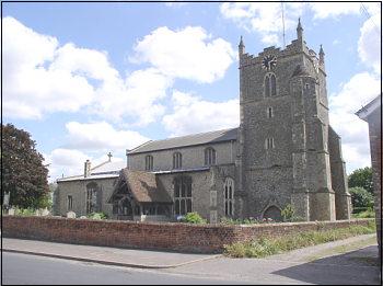
St
Marys Church
Our present St Mary's church is in fact the medieval church of "All
Saints"
How was it that the town and the entire parish (including the Essex
part) could be known as Bures St Mary, while the church was dedicated
to All Saints? A clue appears in a charter of 1071, the earliest
certain appearance of Bures in documented history. Signed by William
the Conqueror himself, the charter refers to the church of St Mary
in Bures. Since, in the first five years after the conquest, the
Normans were far too busy consolidating their power to build new
churches, we can be certain that the Anglo-Saxon church in Bures
was dedicated to St Mary. The town therefore takes its name from
a much older church than our present All Saints.
The present structure dates back to the 14th century, specific items
have been dated to 1330.
|
|
|
Gas Works
It was erected in 1859 with a capital of £800 in £5
shares and called the "Bures Gas Light & Coke Co Ltd"
Reliability was a problem. The Gas Works were built alongside the
river, because of the ease of unloading coal from the barges. However
this arrangement, had one fundamental flaw.
Everytime the river burst its banks, the Gas Works flooded and the
gas supply failed.
The demise of Gas came during the early 1930`s, when electricity
was generated in the village.
Fortunately the owner of the Gas works saw its demise and switched
his interests in electricity generation.
However, with the arrival of the overhead power lines to Bures and
a far more reliable 240v supply, that business also collapsed.
|
|
|
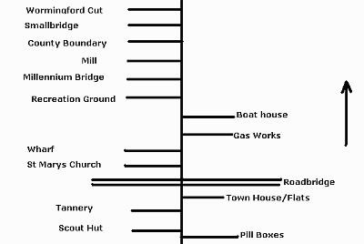
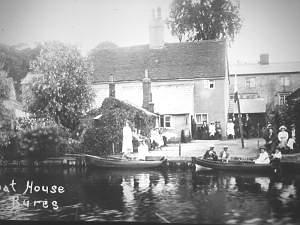
The Boathouse
-
Used for boating trips up and down the river.
Records indicate this business was
in operation from 1902 until at least 1929
|
|
|
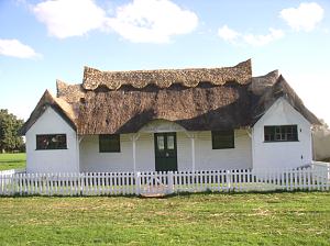
Recreation
Ground
The recreation ground was deemed to be an ideal landing platform
for German paratroopers. Consequently, during 1941 it was covered
in barbed wire by the War Office. In 1945 the Parish Council were
left to arrange removal. The cheapest quote by a local contractor
was agreed at £8, with the contractor retaining the posts
and wire. The Parish Council subsequently made a claim from the
War Dept for the reimbursement of this expense.
Parish records indicate that this money was never forthcoming !
The photograph to the left is the
Cricket Pavillion.
|
|
|
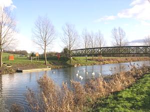
Millennium
Bridge
In November 1997 our two parish councils decided it was time to have
a footbridge across the river. This would make the journey for the
children attending school much safer than walking through the village
and along the main road.
The main construction work on the bridge and footpaths began on 11th
March 2002.
A temporary road had to be built across the recreation ground to support
the bridge when it arrived and for the crane that would lift it in
to place. Once the bridge abutments had been constructed the 32 metre
long bridge was delivered in two sections on two very long articulated
lorries whose progress from Huddersfield was quite newsworthy. Two
weeks later, after the two bridge sections had been welded, together
an enormous (600t) crane arrived and lifted the assembled bridge into
place across the river - there was quite a crowd there to see this!
Then the footpaths, fences and the landing stage were constructed
and everything was completed by the end of June 2002.
The total cost of the project, including access and hard surfaced
pathways was approximately £140,000. |
|
|
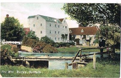
Bures
Mill
The first recorded mill on or near this site at Bures has been dated
at 1190.
In 1640 the timber framed Mill House was erected and extended in 1820.
Part of this structure can still be seen today.
The last barge to the Mill was during 1911.
Flour production ended in 1929.
In 1932 the mill wheel was removed and replaced by a 220hp diesel
engine. However within a year all flour grinding was transferred to
Fingringhoe Mill to take advantage of the waterside transport. Soon
Bures Mill was devoid of all machinery and became a producer of animal
feeds.
1990 was the last year of animal feed production at the Mill and the
end of three generations of milling by the Hitchcock family over a
period of 115 years.
At one time on the Stour and its tributaries there were 30 mills producing
flour. Only three changed to roller milling, which extended their
life span considerably. The three were Dedham (flour milling, closed
1982), Bures (animal feed, closed 1990) and Cornard (pet food, closed
approx 2002). |
|
|
Essex/Suffolk
County Boundary
Documentation dated 1318 refers to a mill and a mill pond called
Crudmelne along the River Stour. It may have even existed as far
back as 1200.
Today the county boundary runs along Wyttisham Ditch, perhaps the
original course of the river, possibly dating back to 950.
Wyttisham Ditch today has disappeared with no evidence left of its
existence.
This clearly leaves the island in Essex.
Because this land is north of the river it should be located in
Suffolk. However this is not the case, it resides in the parish
of Mount Bures. Essex. This anomaly is located due North of Staunch
Farm - the concrete remains of a farm bridge which has been removed
can be seen in the embankment which gives you the approximate location.
|
|
|
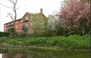
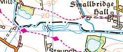
Smallbridge
Hall
Queen Elizabeth I stayed at the Hall in its early years, in 1561
and again in 1579. Whilst it did a lot for the owners status, it
left him £250 poorer having to entertain not only the Queen
but her entourage.
The house is known to have had a chapel in 1600 dedicated to St.
Anne and it also had a gatehouse.
The house was much rebuilt in 1874 and further restored by Lady
Phylis Macrae, daughter of the Marchioness of Bristol in 1932.
During the second world war, it was
briefly used as a home for evacuees from London.
|
|
|
Wormingford
Cut
Although the Wormingford Cut is just a few metres outside the Bures
parish boundary, it`s a fine example of engineering the river to
solve a problem.
To overcome persistent grounding of the "Lighters" in
Wormingford Millpond, a by-pass channel was constructed.
The majority of people who travel along the road past Smallbridge
Hall, are totally unaware the hedgerow conceals a hidden river bed.
Although now dry, it can still clearly be seen from footpaths which
runs alongside the entire channel length.
The new channel had two locks:- Wormingford Lock and Swan Lock.
These locks were required to lower
the water level under the road bridge in order to allow the "lighters"
to pass underneath.
Unfortunately once the traffic ceased
around 1930 the channel became derelict together with the locks.
Today only a few traces of the two
original locks remain
Unfortunately the by-pass channel is now dry as both ends have been
blocked by soil.
This was to prevent the cut flooding from the main river without
any source of control.
|
14.08.07 |