|
The map on the left is dated 1805
and shows the river and the enormous flood plain.
CLICK image to enlarge.(800k pdf file)
The river today is
just a narrow stretch of water, compared to what we see back in
the peak days of navigation.
Between Brantham and Sudbury locks
were located at:-
Cornard, Henny, Pitmere(Lamarsh), Bures, Wormingford(2), Wissington,
Nayland, Horkesley, Boxted, Langham, Stratford, Dedham, Flatford
and Brantham. These were mainly located at the site of "Mills"
where they provided sufficient head of water to operate the Mill.
The lock gates were spaced 95 feet apart to allow the passage of
two `lighters`
However these locks became very unpopular with the local millers
in dry weather, when so much water was lost each time a boat passed
through. Water was essential for the millers in powering their mill
wheels. The miller was in a no-win situation, he was then penalised
if he worked the river to a low depth, when there would be insufficient
water to allow the passage of the vessels.
To keep the millers content, the Navigation Act allowed the passage
of mill stones or other material used for milling to be carried
toll free. The farmers also managed to gain similar concessions
with lime, manure, straw etc.
|
There were also 12 "Staunches"
or Flash Locks, where the water level was very shallow. The "Staunch"
consisted of a single lock gate made entirely of timber which would block
the flow of water. The Barges would wait behind the "Staunch"
until the water level had risen considerably. The gate was then removed
and the Barges would be carried along by this rush or "Flash"
of water over the shallow part of the river. The "Staunch" had
the advantage that the closed gate backing up the water would make the
river upstream more navigable.
However, the disadvantage came downstream with Barges having to fight
this sudden surge in water level whils`t raveling upstream against the
flow. It was also a terrible waste of water each time the "Staunch"
was opened.
Barges on the River Stour
were known as `lighters` and were mostly built in a special basin at Flatford,
which can still be seen today. These `lighters` were similar in every
respect to those barges used on the fens and other waterways.
There can be no better portraits
of these `lighters` and scenery than those painted by John Constable.
|
|
|
|
Horse
pulling Lighters and Flatford Dry Dock by `John Constable`
|
|
Uniquely, the `lighters` operated
in pairs, being permanently shackled bow to stern, rather in the style
of an articulated lorry, the rear lighter being used as a rudder for
the pair. The stern vessel had a single hold with a small cabin at the
rear.
The crew consisted of a captain and a horseman. The latter was often
a small boy, who often rode the horse. The journey from Sudbury to the
estuary normally took about 2 days, with an overnight stop halfway at
Horkesley - where a special "bothy" - or bunkhouse - was provided
for the lightermen.
The `lighters` were usually pulled by just one horse going downstream
and possibly two coming back against the river flow.
Each `lighter` was 47ft in length
by 10ft 9" wide with a depth of 2`8ft.
Each `lighter` could pull 13 tons of freight, this meant that one horse,
was not only pulling the weight of the craft, but also 26 tons of cargo.
The navigation in it`s early
days was very successful.
The inventory for 1750 lists the following goods transported by lighter
from Mistley towards Sudbury:-
|
Oil
|
Pitch
|
Tar
|
Soap
|
Vinegar
|
Glass Bottles
|
|
Resin
|
Glass
|
Paper
|
Tallow
|
Iron
|
Lead
|
|
Butter
|
Apples
|
Nails
|
Grindstones (Millers)
|
Coal
|
Rape Seed
|
|
Sugar
|
Reeds
|
Straw
|
Wheat
|
Flour
|
Peas
|
|
Beans
|
Barley
|
Oats
|
Malt
|
Bran
|
Cloverseed
|
From Sudbury and Bures the
main cargo would have been bricks, tiles, hides and malt that would
have made the journey to London.
Looking up river towards
Sudbury from the Bures roadbridge, the barge towing path would have
been on the left. The horse at Bures would cross the bridge and jumped
back on the `lighter` from the wharf side, which was just below wharf
cottage.
 >>>>>> >>>>>> |
|
|
`White
Horse` painting by John Constable showing the horse hitching
(boating) a lift on the `lighter`
|
|
As it had been impossible
to acquire rights of access for a continuous path on one side of the
river, the Navigation Company did not own the lands, but only paid a
toll. Consequently, the horse was required to cross the river at least
33 times. Now as there were only 16 bridges, the horses were trained
to cross by stepping onto the `lighter` and then jumping off the other
side. Straw was sometimes used to aid stability. It was not uncommon
for a horse to loose it`s footing, slip into the river and drown.
|
|
|
|
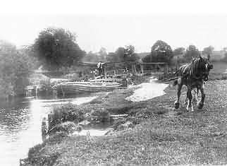
Horse
pulling `lighters` at Wormingford
|
|
In 1836 It was decided to
survey the navigation to see what improvements could be made. The
obvious was to have a continuous towing path on one side of the river
to speed up the journey. If this was implemented the journey time
from Sudbury to Catterwade would be in the region of 12 hours and
the return journey from Mistley taking 14 hours.
Unfortunately this work was never implemented, a disastrous error
!
In 1843 a survey was carried out into
the feasibility of extending the route northwards to Clare.
With the final estimate in excess of £30,000 the scheme was
abandoned.
In 1850, yet another survey was undertaken
and it was estimated the horses had to jump 123 stiles between the
two ends of the journey.
`John Constables` painting, "The Leaping Horse" depicts
this action vividly.
The height of the stiles presented a major problem at some locations.
The Lightermen wanted them lower for their horses, but the farmers
wanted them higher to avoid losing cattle, Stalemate, once again nothing
happened to alleviate this dilemma.
This was to have disastrous consequences in the following years. (see
conclusion)
In 1870 the authorities had
trouble with the Sudbury sewage which was blocking the free passage
of the barges. Apparently the river was getting so bad in some stretches
the Navigation Authority had to spend £600 on a steam dredger
to clear a passage. In 1887 to recoup their expenses it was loaned
out to the "Zeoninite Company" at Brantham for 30/- a week.
Cattawade/Brantham.
In order for the cargo to be transferred from the `lighters` to and
from coastal ships, they were unhooked from their horse at Brantham
and floated on the tide, down to Mistley Quay.
This 2 mile tidal journey provided the most difficult part of the journey.
The horses were left at Brantham and with the help of the wind and tide
they set off for the quay. If the wind was favourable the skipper would
hoist a square sail made out of sacking to assist passage, if all else
failed the `lighter` would be pushed along with a pole.
No mean task on a tidal river together with the weight of the `lighters`
for a distance of 2 miles.
Bricks were the major cargo
originating from works at Ballingdon and Bulmer, going downstream, with
coal and grain returning upstream from Mistley. We all look at the Albert
Hall and perhaps the South Kensingtons museums architecture with some
wonder, but did we appreciate the bricks for those buildings, travelled
through Bures from the Ballingdon Brickwork's on they way to London. The
brickwork's were producing some 3 million bricks per year in the early
1900`s and most of them would be transported by `lighter`.
Mistley was a thriving port
from the time it opened in 1730 importing coal from the North of England
to the Gasworks at Bures and Sudbury together with grain for the Maltings.
Bricks, chalk, flour and straw were exported to London and malt to the
Guinness brewery at Dublin.
Why straw you may ask ?
The horses pulling the London
cabbies, depended on straw and feed brought in by stack barges or "stackies".
These craft were wider in the beam making them handle better. Waste made
by the stable sweepings (London mixture) was then shipped back to the
farms.
The "Brickie" barge could carry between 40 - 45,000 bricks,
enough to build a pair of semi detached houses ...... so which came first,
the size of semi or the size of barge ??
Back to Bures:-
The railway arrived in Colchester
in 1843, which started 40 years of network expansion.
Perhaps seeing problems ahead, in 1846 the Navigation Company reputedly
offered to sell itself to the Railway Company for £30,000. The offer
was refused as was a counter offer made by the Railway Company.
The arrival of the railway
from Marks Tey to Sudbury in 1849, started the inevitable decline in the
use of the river. An attempt was made around 1862 to power barges with
steam engines to cut journey times but this proved a disaster. Fitting
engines to existing `lighters` either caused the propeller to stick out
of the water or foul the river bed because of the meager 3ft draught.
This project was abandoned in 1867.
In hindsight, another disastrous mistake.
In 1879 the Ministry of Agriculture purchased a steam dredger to clear
the river of silt and keep the navigation clear. Within six months this
proved ineffective and compounded by landowners, who would not pay the
tolls for the work.
In 1886 the Navigation company
reported that the trade in bricks was seriously affected by the rail network.
The bricks from Ballingdon continued to be transported, but alas only
from their works to Sudbury Railway Station, where they continued their
journey by rail.
 |
Bures Wharf circa
1900.
The road bridge can be seen to the left and the Wharf to the right.
A "Lighter" can be seen beside the jetty.
This would have handled
outgoing bricks, malt etc.
Coal would have arrived
from Mistley for the Gas works.
|
Surprisingly, maximum tonnages
of various classes of goods were achieved in various years after the various
after the introduction of rail transport as shown by the following list
Coal 22,813 tons (1860)
Wheat 43, 122 Quarters (1862)
Flour 61,382 sacks (1868)
Malt 15,912 Quarters (1851)
Bricks 3,245,450 (1866 and 1864)
Barley & Oats 20, 918 Quarters (1894)
Oil 4096 barrels (1893)
Stiff competition between
river and rail meant fares were cut and more locks (13 to 26) were built
to speed up the journey.
Sadly in 1890 the Navigation Company fell into debt.
Traffic fell from a total
of 20,000 tons annually in the 1890s to 10,662 tons in 1911.
In 1913, there was a pleasure
trip by barge from Bures, commemorating both the end of the navigation
and its 200th. anniversary. One gentleman lost his gold watch overboard
on the occasion and never retrieved it.
The real demise came when the Admiralty decreed (1914 -1918)as a wartime
measure, that all the lighters should be sunk, to make sure they did not
fall into enemy hands. The entire fleet of 14 lighters at Sudbury were
scuttled and they sank into the river at Ballingdon Cut.
Unfortunately the horses also came to the end of their useful life. Sentiment
was not a high priority.
By the outbreak of the First
World War, little freight traffic now remained on the river.
The Navigation Company finally
went into liquidation on September 9th. 1913, a few craft continued to
use the river, paying dues to the Liquidators. The last `lighter` went
up to Sudbury in 1914/15, but Dedham Mill continued to use the barges
until 1930, when Percy Clover, the owner, paid tolls amounting to £1
13s. that year.
The last recorded barge through Boxted Lock was in 1916.
Following the loss of freight
traffic on the river it soon deteriorated, the locks fell into disrepair
and the navigation became unusable.
In 1935 three feet of water was lost from the river following the breakdown
of the floodgates at Wormingford Mill. The gates were never reinstalled
and the river has never regained this full height since.
The Liquidation of the Navigation
Company was finally completed in 1935.
It is now only navigable between Sudbury and Bures, the path south being
blocked locally by a sluice gate at Bures Mill.
Factors affecting its closure:-
(a) arrival of the railway which poached the transportation of bricks
and coal.
(b) the failure of the Navigation Company to pursue the use of steam on
the river
(c) the lack of a continuos towpath, doubling the journey time
(d) with the loss of the brick and coal trade, the lack of reform to find
alternative cargoes.
Finally the River Stour Trust
salvaged a steam powered vessel, dating back to 1862 near to Pitmere Lock.
20/07/2001
Updated 20/09/09
Credit:- Witgar Hitchcock (dec), Bures Mill
& History Society
River Stour Trust, The
Suffolk Stour by Ambrose Waller
|